 |
Welcome to:
Castlereagh NSW Australia
|
|
Welcome to:
Castlereagh NSW Australia
|
| Location: Where is Castlereagh? | |
| Castlereagh, New South Wales, Australia is located east of the Nepean River north of Penrith. This suburb is one of the most historic sites in Australia's history, being one of Governor Lachlan Macquarie's five towns founded in 1810. After two hundred years, the rich river flats continue to provide for a thriving agricultural industry along the Nepean River. Many of this district's pioneering families originated from Castlereagh. The suburb's historical importance is reflected in its many surviving farmhouses, outbuildings, churches and cemeteries. Castlereagh Road is an important transport link connecting the Hawkesbury and Penrith regions. The impact of the massive Penrith Lakes Scheme has, and will in the future, change the face of Castlereagh and its neighbouring suburbs. | 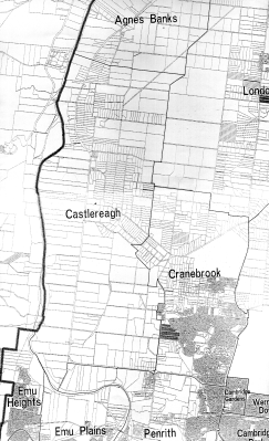
33 40'00"S 150 41'00"E |
Postcode: 2749 Population: 1329 (1996 Census) Distance from Sydney: 67 klms
|
Local Government: Castlereagh is located in North Ward of the Penrith Local Government area. Use the blue link to view a map of the Local Government area showing its corresponding wards, and, the City of Penrith Councillors. These details will remain current until Local Government elections in September 2003. |
| State Government: Castlereagh is located in the State Government Electorate of Londonderry.Next elections are scheduled for March 2003. |
| Federal Government: Castlereagh is located in the Federal Government Electorate of Lindsay. Next elections are scheduled for 2001. |
| Aboriginal
Districts: Castlereagh is located in the Deerubbin Local
Aboriginal Land Council Area.
_____________________________ |
Community Profile
This profile is
a snapshot of the suburb of Castlereagh as a community.
Community Services
Bus Services
Westbus Pty. Ltd. Head Office (02) 9683 2344 All timetables are shown for
Castlereagh.
Child Care Services
Ph. 4776 1280.Halls
(ring after 4.30pm).Schools
Ph. 02 47774057. In 2000 Junior High School began.Social Issues
1996 Census of Population and Housing
Selected Characteristics Male Female Persons Total Persons 698 631 1329 Aged 0-4 55 36 91 Aged 5-9 56 50 106 Aged 10-14 57 47 104 Aged 15 years and over 551 506 1057 Aboriginal 11 4 15 Torres Strait Islander 0 0 0 Australian Born 561 493 1054 Born Overseas 121 120 241 Speaks English only (over 5 years) 562 503 1065 Australian Citizen 631 565 1196 Living in private dwellings 698 631 1329 Living in Non-Private Dwellings 0 0 0
| Housing Selected Statistics | Fully owned | Being Purchased | Rented | Occupied - Rent Free | Unoccupied | Total |
| Separate Houses | 205 | 90 | 56 | 16 | 17 | 408 |
| Semi-detached House | 0 | 0 | 0 | 0 | 0 | 0 |
| Flats | 0 | 0 | 6 | 0 | 0 | 6 |
| Caravans | 0 | 0 | 0 | 0 | 0 | 0 |
Source: CDATA96. Australian Bureau of
Statistics 1996 Census of Population and Housing.
For more details on
Castlereagh (or any other areas in New South Wales) from the 1996 Census, please
contact Penrith Library Research Services 02 4732 7886, or call in to Penrith
City Library Civic Centre 601 High Street Penrith, NSW 2750 and view CLIB96. It
is available on open access at Penrith, St. Marys and St. Clair
Branches.
Landscape Profile
Urban Bushland In Western Sydney: Proceedings of a
Seminar held at Werrington Campus, University of Western Sydney, March 23rd
1991. First published in Australia 1992, by the Nature Conservation Council of
NSW, 39 George St., Sydney 2000.
Copyright Nature Conservation Council of
NSW.
The Native
Vegetation Of Western Sydney
Castlereagh Woodland
by
D. H. Benson, Royal Botanic Gardens, Sydney. This paper is drawn largely from
our recent books on Sydney vegetation, Benson & Howell (1990) and Benson
& McDougall (1991).
Castlereagh Woodlands
The
Castlereagh Woodlands are found on the Tertiary alluvial deposits and include
Ironbark Forest, Scribbly Gum Woodland and Swamp Woodland, each growing in
slightly different conditions. Ironbark forest with Broad-leaved Ironbark,
Eucalyptus f brosa is found on deep, well-drained reddish clay soils; examples
can be seen around Castlereagh. Eucalyptus f ibrosa is the dominant tree
species, generally forming pure stands, but it may also be associated with Mugga
Ironbark, Eucalyptus sideroxylon and Narrow - leaved Ironbark, Eucalyptus
crebra. A small -tree layer of Melaleuca decora and an understorey of
sclerophyllous shrubs to 2 m high is generally conspicuous. No particular
species predominates in the understorey, although the pea family Fabaceae is
well represented. Shrub species which may be locally abundant are Dillwynia
tenuifolia, Dodonaea falcata, Hakea sericea, Melaleuca nodosa, Mirbelia
rubiifolia and Pultenaea villosa. A number of species and forms are endemic to
the Castlereagh Woodlands.
Scribbly Gum Woodland is found on sandy soils
of the Tertiary alluvium, in the Castlereagh-Londonderry area and
at
Holsworthy. Eucalyptus sclerophylla and Angophora bakeri are the most
common species. Other tree species that may
be present are Eucalyptus
fibrosa, Eucalyptus eugenioides, and very rarely, Eucalyptus gummifera. The
understorey; consists of sclerophyllous shrubs which may form a continuous cover
or be more open, with grasses in between. Common shrub species are Banksia
spinulosa, Grevillea mucronulata, Hakea sericea, Leptospermum trinervium
and
Melaleuca nodosa. Swamp Woodland with Eucalyptus parramattensis,
Eucalyptus sideroxylon and Melaleuca decora is found in poorly drained
situations. Open-forest of Eucalyptusfibrosa is found with Grey Box, Eucalyptus
moluccana, on the transitional zone between Wianamatta Shale and Tertiary
alluvium. A mixture of species is found on these two soil types.
Eucalyptusfibrosa, one of the most common species on the Tertiary alluvium and
Eucalyptus moluccana, a common species on Wianamatta Shale, dominate. Other tree
species present include Eucalyptus eugenioides and Eucalyptus sclerophylla. The
understorey is dominated by low shrubs with a mixture of the hardier species
from the Wianamatta Shale and Tertiary alluvium. Bursaria spinosa, Daviesia
ulicifolia, Dillwynia juniperina, Hardenbergia violacea, Exocarpus
cupressiformis, Melaleuca nodosa and Acacia parramattensis are the most common
species. Smal1 trees of Melaleuca decora are often conspicuous.
SITE No: AGB4 AGNES BANKS: Penrith City
Council, Penrith
City Remnant Native Vegetation Survey, August 1995.
LOCALITY : CASTLEREAGH PUBLIC SCHOOL POST OFFICE
RD., CASTLEREAGH
ZONING: RURAL 'B', LEP 201
DATE : MARCH/APRIL 1991
MAP No : 6467-2
TOPOGRAPHIC MAP:
Springwood
GEOLOGY: Londonderry
Clay
SOIL: Mulgoa
VEGETATION: Agnes
Banks Woodland
SITE DESCRIPTION:
A significant stand
of Broad Leaf Ironbark and a Melaleuca decora understorey. Severe grazing impact
has reduced the
ground covers diversity. The roadside verge outside the site
had a rich mix of native ground covers including glycine and
hardenbergia
species. The site occupies a significant landmark position on Castlereagh Rd and
the Ironbark stand is an
important element on the
skyline.
SPECIES:
Eucalyptus fibrosa / E. tereticornis /
Melaleuca decora / M. linearifolia
A significant educational and
community resource given its. location.
Number of lakes - 6
the Nepean Piver about 11 km.The area 3km north of Penrith, known now as the
Penrith Lakes Scheme and operated by a conglomerate of companies that
combined their landholdings and quarrying operations in 1979 (i.e. Boral, CSR,
and Pioneer International), is by far the largest extractive site in the area. This site
supplies around 75% of Sydney’s sand and crushed aggregate requirements,
including about 85% of the materials for ready mixed concrete.
Internet Links
Sydney International Regatta Centre, Penrith
School. A new recreation area for Sydney's West.
Castlereagh Equestrian Centre: Castlereagh Road, Castlereagh.
Ph. 02 4776 1132.
Robrick Lodge
A 20 hectare horse stud with 31 fenced paddocks, each with sheltered sheds, along with stables and colt yards. Robrick Lodge is located on the alluvial flats fronting the Nepean River. This stud will be auctioned on 15 July 1999 by Raine & Horne. Contact Joe Parker or Michelle Camplin on 02 47321000 for more details.
Saintly: The Heavenly Horse now lives at Princes Farm, Castlereagh Road, Castlereagh. Among his 23 starts , 10 wins, 8 seconds, and 3 thirds he won the Flemington Cup, Rosehill Stakes, WS Cox Plate, Melbourne Cup (1996), and the Caufield Stakes with prizemoney of $3,851,765.Princes Farm
Bart Cummings spelling and pre-training horse property on Castlereagh Road & Smith Road, Castlereagh near Penrith NSW.
Source: Turf Monthly, May 1997, p. 38.
'Saintly starts the long haul back', Sydney Morning Herald, 1 May 1998.
'Master unearths a buried treasure', Sydney Morning Herald, 1 May 1998.
Aboriginal
History
Information on Aboriginal
history in Castlereagh is limited. Please see The Dharug
Story for more general information. For information on the Aboriginal
population of Castlereagh from the 1996 Census of Population and Housing see
Community Profile for Castlereagh.
Origin of the place name -
Castlereagh
This suburb takes its name from the Irish peer,
Lord Viscount Castlereagh (1769-1822), who was responsible for the Act of Union
between Ireland and England in 1803. Governor Lachlan Macquarie named the area
in December 1810 during a tour of the Hawkesbury-Nepean region not long after
his arrival in the Colony of New South Wales. Macquarie chose Castlereagh as one
of his five towns, the others being Windsor, Richmond, Wilberforce, and Pitt
Town. Castlereagh was designed to provide storage space and accommodation for
the local community, especially during flood time. In his journal on 6 December
1810 Macquarie wrote 'The township for the Evan or Nepean District I have named
Castlereagh in honor of Lord Viscount Castlereagh'. A sign bearing the name
Castlereagh was erected in 1811 after the streets and a town square had been
marked out by the surveyor James Meehan.
Circumstances however, ensured that Penrith, not Castlereagh, became the focal point of the area and this site was never developed. The present township is located five kilometres away from Macquarie’s original site.
Bibliography [all items held by Penrith City Library] :
Murray, Robert and White, Kate Dharug & Dungaree: The History of Penrith
and St.Marys to 1860, Penrith City Council, Penrith, 1988.
Nepean District Historical Society, From Castlereagh to Claremont
Meadows: Historical Places of Penrith City Council,
Penrith,1997.
Castlereagh Centenary Committee, Castlereagh Centenary
1895-1995, 100 years of Local Government, Penrith, 1995.
Historical Timeline
| 1799 | A major flood of the Nepean River | |
| 1803 | 1 July | Mary Collett received a land grant at 'Birds Eye Corner'. |
| 1804 | 4 June | John Lees received land grant at Castlereagh. Later he gave part of this grant for a Methodist Church to be erected. |
| 1804 | 11 August | James McCarthy received land grant which he later named Crane Brook Farm. |
| 1806 | A major flood of the Nepean River | |
| 1809 | A major flood of the Nepean River | |
| 1810 | 6 December | Governor Lachlan Macquarie named Castlereagh as one of his five towns |
| 1811 | Surveyor James Meehan marked out the streets and square | |
| 1811 | A major flood of the Nepean River | |
| 1814 | 28 April | A glebe house and school completed for Rev. Henry Fulton in Church Street |
| 1814 | 11 July | Rev. Henry Fulton's school opened. Called the Classical Academy for Young Gentlemen, this school was the first secondary school in Australia. |
| 1814 | First burial in Castlereagh Anglican cemetery | |
| 1817 | 7 October | The first Methodist chapel in the southern hemisphere was opened, erected by John Lees |
| 1818 | 4 January | James Tobias 'Toby' Ryan born at Castlereagh |
| 1822 | John Single built 'Nepean Park' | |
| 1825 | Rev. Henry Fulton's school was closed | |
| 1826 | 22 February | Joseph Daniel Single born |
| 1836 | 4 August | Ann Fulton, wife of Henry Fulton died |
| 1836 | John Lees died at Castlereagh | |
| 1840 | 17 November | Rev. Henry Fulton died and is buried at Castlereagh Cemetery on the 19th Nov. |
| 1848 | Methodist Chapel opened - the second on the site | |
| 1858 | 1 May | Castlereagh School opened. It closed in 1935. |
| 1878 | 11 December | Christchurch Anglican Church was consecrated. This church replaced Fulton's church in Church Street which had been destroyed by fire. |
| 1878 | 28 January | John Single of 'Nepean Park' estate died. |
| 1879 | 3 March | Upper Castlereagh School opened. It closed in 1975. |
| 1895 | 9 September | Municipality of Castlereagh proclaimed. |
| 1911 | 26 September | William Hart flew over Castlereagh and up the river to Edinglassie, the first aeroplane flight in the district. |
| 1923 | First cotton grown in Australia at Castlereagh by G. A. Bond & Co. on the corner of Church Lane and Castlereagh Road. | |
| 1935 | 17 December | Castlereagh School closed. |
| 1948 | 12 August | Announced that Castlereagh Council would amalgamate with Penrith not Windsor and Richmond as previously recommended. |
| 1948 | December | Elections held for the new Council. |
| 1949 |
1 January |
Castlereagh, Mulgoa, St. Marys and Penrith Shires amalgamated to form the Municipality of Penrith. |
| 1957 | The present Castlereagh School erected. | |
| 1980 | Penrith lakes Scheme established. |
Family History Links
![]() Single
Family History - John and Sarah Single, Castlereagh.
This page is part of a more extensive page on the Alford Family. The index of names is very
useful.
Single
Family History - John and Sarah Single, Castlereagh.
This page is part of a more extensive page on the Alford Family. The index of names is very
useful.![]() Rope-Pulley Family
History
Rope-Pulley Family
History
|
Historic buildings & places | |
|
'Hadley
Park' Source: |
Source: Penrith City Library Photographic Collection LCPH E018. |
|
'Nepean
House' Source: |
Source: Penrith City Library Photographic Collection LCPH R042.. |
|
Christchurch Anglican Church The first Anglican Chruch was built in
1813 within the surveyed town of Castlereagh. This church was destroyed by
fire in the early 1870s. Christchurch was consecrated in 1878 and is
located in Church Lane overlooking the fertile river
flats. |
Source: Penrith City Library Photographic Collection LCSL V26. |
|
Upper Castlereagh Methodist Church & Cemetery The land on which the first Wesleyan
Church built in Australia stands was part of a grant to John Lees in 1804.
In 1817, the small chapel was opened. In 1848, the Church was replaced by
the present stuccoed builiding. The cemetery was opened in
1836. |
Source: Penrith City Library Photographic Collection LCSL EE20. |
|
Castlereagh Hall
The Muncipality of Castlereagh was
proclaimed in 1895. This building was built as part of the Council's
depression relief during the early 1930s. The muncipality was amalgamated
with Penrith Council in 1949. |
Source: Penrith City Library Photographic Collection LCSL EE17. |
Historical
Castlereagh Centenary Committee, Castlereagh Centenary 1895-1995, 100 years of Local Government, Penrith, 1995.
Edds, Graham, & Associates "Hadley Park": RMB 113
Castlereagh Road, Castlereagh NSW: Conservation Management Plan,
1996.
Heritage Study of Penrith, 1987.
Murray,
Robert and White, Kate Dharug & Dungaree: The History of Penrith and
St.Marys to 1860. Penrith City Council, Penrith, 1988.
Nepean District Historical Society, From Castlereagh to Claremont Meadows: Historical Places of Penrith City Council, Penrith,1997.
Parr, Lorna, A History of the Nepean and District Street Names, Nepean District Historical Society, Penrith, 1990.
Parr, Lorna, Penrith Calendar, Nepean District Historical Society, 1987.
Parr, Lorna, Penrith City Library Oral History Project, 1997.
Pollett, R. John & Sarah Single: A Genealogical History of the Single Family, 1991.
Stevenson, Colin R., Place Names and their Origins within the City of Penrith, Penrith City Council, Penrith, 1985.
Stickley, Christine, The Old Charm of Penrith, 2nd ed., the author, St. Marys, 1984.
Compiled by Lorraine Stacker,
Research Services Librarian, Penrith City Library.
Please e-mail your
comments.
Penrith City Council Library Service
Copyright ©
2001 by Penrith City Council. All rights reserved.
Revised: 20
March 2001